Editor's Note
March 22 marks this year’s World Water Day and the start of the following China Water Week from March 22 to 28. The theme of the 2025 World Water Day, Glacier Preservation, calls on the global community to protect our planet’s precious frozen freshwater resources. To raise the awareness about this urgent mission, the United Nations has designated March 21, one day before the World Water Day, as the World Glacier Day, beginning from this year.
In celebration of the World Water Day and China Water Week, and to highlight China’s achievements in water resources development and its contributions to the global water sustainability, the Chinese government has set the theme of China Water Week 2025 as “Promoting High-quality Development in the Water Sector for National Water Security.” In response to this initiative, IWHR has published a special series of feature articles, exploring cutting-edge developments in smart dam construction, digital twin technologies, river ethics, and the National Water Network.
This series showcases the institute’s contributions to national strategies, livelihood improvement, scientific and technological advancement in the water sector, and international cooperation. It also highlights how innovations in water science and technology are shaping new productive forces and contributing to global sustainable development.
Digital twin technology for basin-scale flood control has emerged as a cutting-edge innovation in the field of information technology, playing a pivotal role in building a modern, secure, and resilient National Water Network. By leveraging advanced technologies such as big data, cloud computing, and artificial intelligence, this approach constructs highly realistic digital replicas of physical river basins. Through integrated processes including data acquisition and transmission, data processing and analysis, knowledge construction and discovery, as well as model development and integration, digital twins enable real-time monitoring, simulation analysis, optimized scheduling, and decision-making support for flood control operations, significantly enhancing the scientific rigor and precision of flood management decisions.
A Milestone in IWHR’s Smart Water Development: Digital Twin for Flood Control
Since 2021, guided by policies and technical requirements from the Ministry of Water Resources and grounded in years of independent research, the flood control digital twin research team at IWHR has been advancing a comprehensive digital twin system for flood control. Initial pilot projects were launched in the Huaihe and Haihe River Basins to explore the technical framework. In 2022, the team extended the application to key river basins in Shandong Province, specifically the Dawen and Yishu Rivers, focusing on the forecasting, early warning, simulation, and emergency planning for flood control and disaster mitigation. By integrating infrastructure such as reservoirs and sluices within the basin, the team initiated the development of a unified system combining big data, knowledge, and large-scale models, achieving preliminary results in flood risk forecasting, simulation, and emergency planning.
By 2023, the team had developed and implemented key components such as the basin-level data base reconstruction technology, the knowledge framework for flood prevention and mitigation, and integrated large-model platforms for flood control. In 2024, the system evolved further with the construction of a comprehensive big data framework and the deep integration of the flood control large model with modules for water resource regulation, water project management, and AI-powered intelligent decision-making. These advancements have fully supported the development of Henan Province’s digital twin water resources platform, enabling full implementation of forecasting, early warning, simulation, and emergency planning capabilities across flood control, water resource management, and water infrastructure operations—marking a major leap toward version 3.0 of China’s digital twins of water resources technology system.

Timeline Diagram
Data–Knowledge–Model: The Three Core Engines of IWHR’s Smart Water Strategy
Through years of exploration and practice, the IWHR research team has developed a digital twin flood control technology system for river basins centered on three interlinked engines, namely data, knowledge, and models, guided by the flood preparedness management framework. By connecting the Four Situations (rain, water, emergency, and disaster) and reinforcing the Four Key Links in Flood Defense (Rainfall–Runoff–Confluence–Flood Evolution, Basin–Mainstream–Tributary–Cross-Section, Total Volume–Peak Flow–Process–Regulation, and Technology–Materials–Teams–Organization), this system advances water-related disaster prevention by transforming data from isolated silos to holographic integration, knowledge from experience-driven to knowledge graph-based, and models from static and single-use to dynamic and coupled, fully enabling data-empowered flood control and drought mitigation.
Data as the Foundation for a Fully Perceptive, Standardized Smart Water Internet: A unified big data system referred to as a Smart Water Internet has been established by constructing an integrated data-lakehouse digital resource pool with standardized data governance. A “one-code, multiple-form” spatial data organization and representation model enables full connectivity across data types while ensuring procedural, standardized, and secure data governance. Following the principle of managing data with water and managing water with data, the system manages data circulation based on hydraulic structures such as lakes, reservoirs, rivers, and sluices, achieving orderly spatiotemporal integration of diverse datasets. This provides solid foundational data support for applications in flood forecasting, water resources management, and other digital twin application senarios.
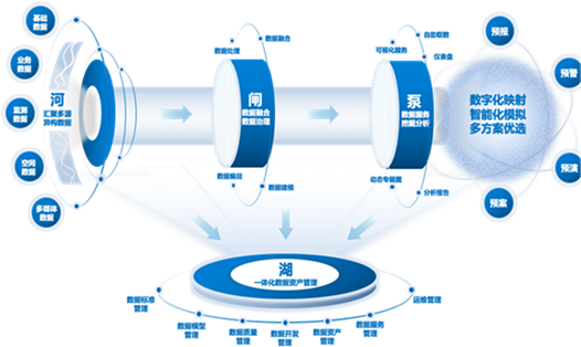
Integrated Data-Lakehouse Flood Control Digital Resource Pool
Knowledge as Empowerment for a Genetic Library of Water Governance: in the domain of knowledge, IWHR has constructed a comprehensive water knowledge base spanning 17 disciplines and 103 specialties. Emphasizing knowledge structuring, reasoning, and interpretability, the research team has established a flood control knowledge dictionary through formalized definition and labeling. Guided by three core lines—business processes, management workflows, and technical chains—the system integrates large language models such as DeepSeek to build a data–information–knowledge–application-centered knowledge architecture. This system includes 15 major categories, 53 subcategories, and 96 microdomains of specialized knowledge, forming a knowledge matrix that supports relationship inference, historical experience learning, and expert knowledge inheritance. It acts as a smart advisor that is always accessible, shifting water governance from reliance on intuition and experience to a science-based paradigm.
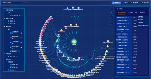
Knowledge Graph
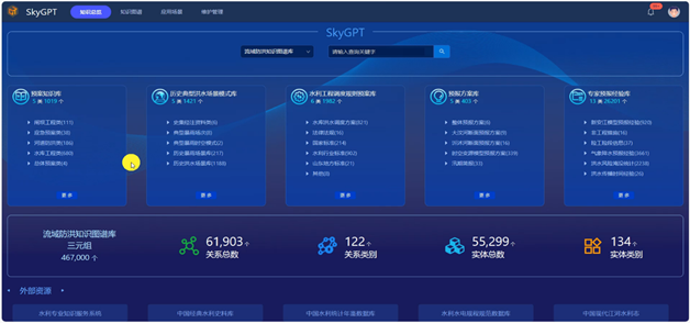
Knowledge Q&A
Model-Driven Decisions for a Super Brain for Future Prediction: On the modeling front, IWHR has developed and integrated the SkyLIM large model based on its proprietary SkyDI model toolbox, forming a sector-wide general-purpose modeling platform. This platform standardizes and encapsulates 89 hydrological and water resources professional models, artificial intelligence models, and large language models, all registered and managed under a unified system. It offers over 120 service interfaces for data access and model computation. Applications span diverse scenarios, including basin flood control, water resources scheduling, reservoir group operations, and infrastructure monitoring, supporting full-element, holographic, and immersive simulation and retrospection.
With a “multi-user, multi-scenario, multi-model, multi-state” approach to model management, the system supports digital twin applications at national, provincial, and municipal levels, enabling a complete transformation from conceptual modeling to physical mechanism simulation. This evolution allows water management strategies to shift from reactive responses to proactive, preemptive planning and intervention.
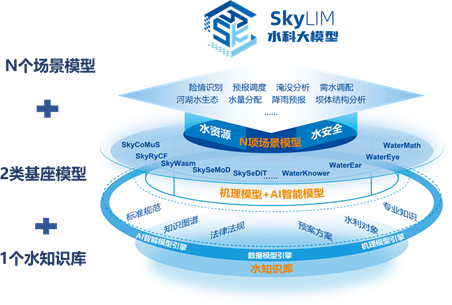
Technical Architecture of the SkyLIM General Water Science Foundation Model
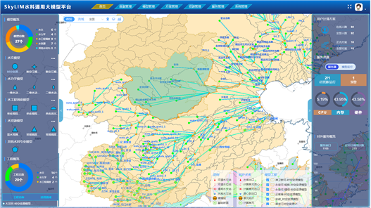
SkyLIM General Water Science Foundation Model Platform
Empowering with Digital Intelligence for Transition from Traditional Water Management to Smart Water Governance
Empowered by data, sustained by intelligence—this is the vision of Smart Water. In 2024, IWHR leveraged its digital twin flood control technology system to achieve a 95.2% accuracy rate in predicting and forecasting river discharge at key sites on the Yishusi River in Shandong Province four hours in advance. The system also provided full-process technical support for emergency response in Dongting Lake, including breach closure, embankment defense, construction of third-line barriers, and internal drainage. Moreover, it played a critical role in supporting the construction and application of provincial-level digital twin water platforms such as that of Henan Province.
After four years of continuous development, deployment, and refinement, IWHR’s digital twin flood control system has evolved from simple data integration to in-depth knowledge accumulation, and from model innovation to practical breakthroughs. This progress marks a steady transformation from traditional water governance (“Zhishui”) to smart water governance (“Zhishui” with AI).
Looking ahead, as our world faces increasingly complex and dynamic water challenges, IWHR will remain dedicated to advancing digital twin technologies. Through a data-driven, knowledge-led, model-enabled, and application-oriented approach, the institute will empower the transition of water management from passive disaster response to proactive and smart water governance, thus accelerating the water sector’s journey into a new era of Smart Water.
Content provided by IWHR Research Center on Flood and Drought Disaster Reduction
English translation by IWHR Department of International Cooperation