Contributors: Fei DONG, Wenqi PENG, Xiaobo LIU, Xuekai CHEN, Weihao WANG, Jiannan ZHANG, Wenqiang WU, Bing MA, Jinjin LI, Aiping HUANG
The Recommendations of the CPC Central Committee for Formulating the 15th Five-Year Plan for Economic and Social Development explicitly states: "Comprehensively implement the 'AI+' initiative to lead the transformation of scientific research paradigms through artificial intelligence", "Improve systems for ecological environmental standards, monitoring, evaluation, and assessment," and "Strengthen monitoring, forecasting, and early warning for meteorology, hydrology, and geological hazards". However, existing unmanned vessel products are generally disconnected from the actual needs of the water conservancy industry. They lack a systematic analysis of and targeted response to operational challenges across different levels—from top-level design to on-the-ground execution—such as difficulties in in-situ high-frequency monitoring, low efficiency in multi-element identification, and insufficient accuracy in pollution source tracing. Consequently, they fail to support core tasks such as revitalizing river and lake ecosystems, constructing data foundations for digital twin basins, ensuring water source safety, and managing emergency responses to sudden water pollution incidents. Therefore, there is an urgent need to focus on the central tasks of water conservancy and develop "multi-purpose" USVs (unmanned surface vessels) for intelligent monitoring and identification of water ecological environments, providing reliable technical equipment support for promoting high-quality water conservancy development in the new stage.
· Focusing on national and industry core needs and typical application scenarios such as digital twin water conservancy and river-lake ecological assessment, develop a "modular block-style" USV for intelligent monitoring and identification of water ecological environments;
· Develop an intelligent identification model for water-related elements suitable for USV deployment, along with an onboard industrial computer computing power solution;
· Develop an automatic layered water sampling and in-situ monitoring system based on a combination of the rotating winch and the winch for vertical operations;
· Construct an intelligent model for pollutant concentration field scanning and pollution source analysis.
· Innovatively proposed an R&D strategy based on a "modular block-style" system. By following a technical path advancing from practical needs through scenario construction, function realization, and software-hardware integration, to the finalizing of hull adaptation, a "multi-purpose" USV was developed for intelligent monitoring and identification of water ecological environments, providing reliable technical equipment support for promoting high-quality water conservancy development in the new stage.
· Constructed a detection framework based on a multi-scale convolutional neural network, and developed a lightweight, low-power intelligent identification model and computing module suitable for USV, achieving real-time dynamic identification of seven categories of water-related elements. This breakthrough has overcome technical bottlenecks in dynamic perception and real-time identification of water-related elements in rivers, lakes, and reservoirs.
· Developed an automatic layered water sampling and in-situ monitoring system based on a combination of the rotating winch and the winch for vertical operations. This system achieved real-time, in-situ, and layered monitoring and sampling across a 10-meter water depth profile, overcoming challenges in vertical sampling and monitoring accuracy for deep and large lakes/reservoirs, and enabling high-frequency perception and dynamic assessment of water environmental elements across the profile.
· Integrated A-Star and improved artificial potential field algorithms to construct an intelligent model for pollution field scanning and source tracing analysis. This has enhanced the range of pollution perception and outlet identification capabilities and achieved autonomous cruising for pollutant concentration fields and pollution source tracing, with a scanning error of ≤15%.
The research outcomes are deeply oriented towards national and industry needs, such as the construction of digital twin water conservancy. Completed and put into operation in January 2024, they have been successively applied in more than 20 typical rivers, lakes, and reservoirs across regions, including the Eastern Route of the South-to-North Water Diversion Project (North Extension), Guizhou, Shandong, Gansu, and Liaoning. The application scale covers multiple important reservoirs and major water diversion projects nationwide, supporting scenarios such as monitoring river discharge outlets and managing riverbank zones. These outcomes provide key technical support for assessing river-lake ecological revitalization, preventing and controlling pollution source tracing, constructing data foundations for digital twin water conservancy, and supporting the "Four Pre" (Forecast, Warning, Preview, Plan) operations.
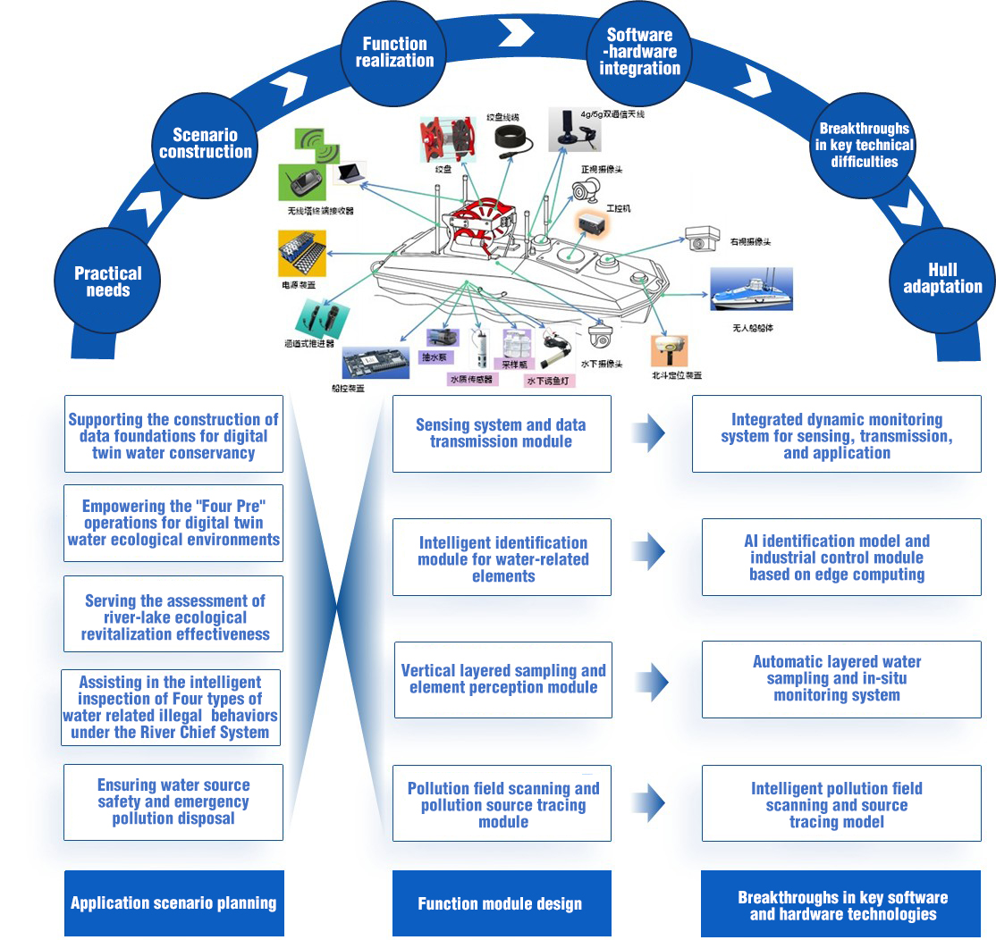
Figure 1. R&D Strategy of the AI-powered USV for Monitoring and Recoginition in Water Ecological Environments
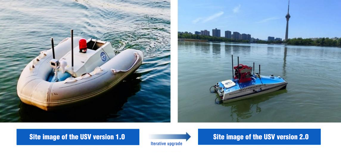
Figure 2. Field Operation Images of the AI-powered USV for Monitoring and Recoginition in Water Ecological and Environments
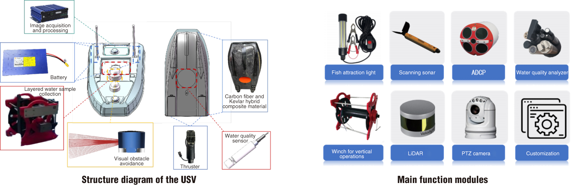
Figure 3. Schematic diagram of USV Structure and Its Function Modules
