
Cao Wenhong, Qin Wei, Ding Lin, Xu Haichao
I. Background Overview
Soil erosion models remain the core of and play a key role in smart soil and water conservation, as necessary for evaluating the status, variation, impacts, and effectiveness of control measures of soil erosion. IWHR, designated by China’s Ministry of Water Resources (MWR) after thematic studies, has been taking the lead in the project named “Research and Development of the National Soil Erosion Model.”
The research team will be working on the “1+7” model set during the 14th Five-Year Plan period – one optimized model and system for dynamic national monitoring of water loss and soil erosion conditions, and seven specific models respectively for soil erosion and gravitational erosion on the northwest Loess Plateau in China, soil erosion in erosion gullies in the black soil region in Northeast China, soil erosion in windy and sandy areas in North China, early warning of anthropogenic water loss and soil erosion risks, comprehensive control and smart management of soil erosion, and flood forecasting, warning, exercise and preparedness for soil-retaining dams.
By the end of 2024, a system of soil erosion model that covers main regions in China and erosion types and fullfills major application needs will be preliminarily established, as a way to meet the requirements of smart soil and water conservation and make it more scientific, efficient and targeted.
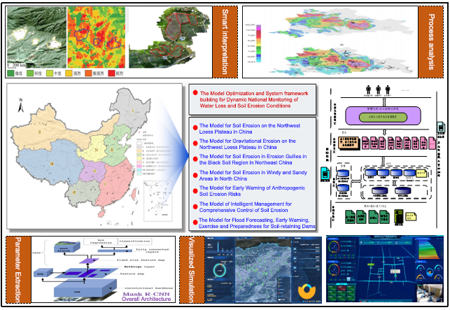
Figure 1 Main tasks of the R&D of the National Soil Erosion Model during the 14th Five-Year Plan period
II. Current achievements
The project was officially launched on March 3, 2022. Up to the end of September, basic data was collected for each model, with the data backplane for model research and development basically formed.
The following achievements have been made for each model:
(1) The Model Optimization and System framework building for Dynamic National Monitoring of Soil Erosion Conditions:
· Having optimized the factors for measuring hydraulic erosion, including improved methods and increased precision of spatial interpolation for rainfall erosivity factors, refinement of value-taking for biological, engineering and tillage practices factors, and updated national soil erodibility factor and related space mapping;
· Having designed a national soil erosion system platform and related functional modules, and having preliminarily developed a platform for dynamic monitoring, collaborative interpretation and model calculation of national soil erosion conditions which can support online interpretation of polygons, factor analysis and erosion calculation.
(2) The Model for Soil Erosion on the Northwest Loess Plateau in China:
· Having evaluated the suitability of the GeoWEPP and other models for the Loess Plateau;
· Having analyzed the sensitivity and key factors of the production process of flow and sediment generation in the loess region.
(3) The Model for Gravitational Erosion on the Northwest Loess Plateau in China:
Having preliminarily analyzed the main types, distribution patterns and influence factors of gravitational erosion, and having identified the geomorphological patterns of its occurrence and distribution.
(4) The Model for Soil Erosion in Erosion Gullies in the Black Soil Region in Northeast China:
· Having preliminarily developed the technology for automatic identification and extraction of erosion gullies in high-resolution images based on residual and convolutional neural network models;
· Having selected the EphGEE ephemeral gully erosion model framework.
(5) The Model for Soil Erosion in Windy and Sandy Areas in North China:
Having established a database of North China for SWEEP wind erosion models and having analyzed the contribution of different factors to wind erosion.
(6) The Model for Early Warning of Anthropogenic Water Loss and Soil Erosion Risks:
Having screened out effective sample polygons for thematic analysis based on remote sensing monitoring data on regional water and soil conservation.
(7) The Model for Comprehensive Control and Intelligent Management of Soil Erosion:
· Having preliminarily developed an indicator system to evaluate the urgency and comprehensive effectiveness of soil erosion control in small watersheds;
· Having defined the quantification criteria and algorithms for that system.
(8) The Model for Flood Forecasting, Early Warning, Rehearsal and Contingency Planning for Soil-retaining Dams:
· Having preliminarily developed digital twin scenarios for watersheds;
· Having generally built a flood risk warning model for soil-retaining dams.
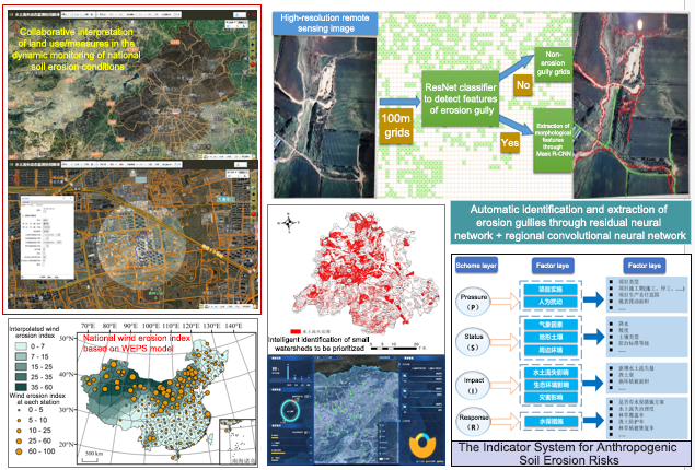
Figure 2 Summary of current achievements made by the project
(Authors are from the Department of Sediment Research, IWHR)