Main Participants: ZHANG Xiaoming, HU Chunhong, AN Cuihua, ZHANG Zhihao, ZHAO Yang, YU Kunxia, XU Mengzhen, GAO Jianling, LI Peng, LIU Hongzhen, ZHANG Tiegang, XIN Yan, ZHANG Yonge, HU Haihua, WANG Yousheng
1.1 Background
The imbalanced relationship between water and sediment, i.e. inadequate water and excessive sediment, is the crux for the Yellow River management. In view of the complex environmental changes, there are still many difficult and critical scientific problems to be solved in water and sediment in the Yellow River Basin. For example, whether the confluence mechanism and the pattern of sediment production and transport on the Loess Plateau have changed, how to break down the nonlinear coupling effects of management measures at different spatio-temporal scales, how to scientifically evaluate the future changes of water and sediment in the Yellow River, and how to regulate the water and sediment balance in the whole basin under new conditions. In light of the national needs and scientific challenges, the research team systematically answers the following questions through comprehensive research: how and why the water and sediment in Yellow River has changed, what is the future trend and how to achieve coordinated regulation. The findings of this research provide technical support for a better coordination of water-sediment regulation and collaborative governance of the Yellow River Basin.
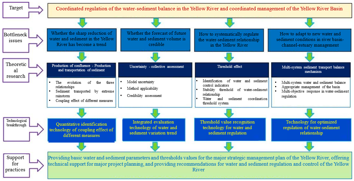
· Research on basic theories: the evolution law of water and sediment in the Yellow River is analyzed on a centennial scale and the multi-factor coupling driving mechanism of water and sediment changes in the basin and the contribution rate of each factor have been identified ;
· Research and development of key technologies: R&D of collective assessment technology for water and sediment changing trends in the basin have been carried outto predict the Yellow River water and sediment volume in the next 30-50 years;
· Support for Yellow River management practices: to maintain the health of the Yellow River, a system of threshold values for water and sediment regulation is proposed, and technologies for water and sediment regulation in the Loess Plateau and the Yellow River Basin under new water and sediment conditions are put forward;
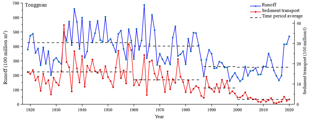
· The research has revealed the evolution mechanism of water and sediment in the Yellow River basin on a centennial scale and the coupling driving mechanism of multiple management measures, identified the contribution rate of individual measures and the combined effect of different measures in the reduction of the Yellow River sediment volume, identified the characteristics of flood and sediment production and transport and the effectiveness of soil and water conservation in rainstorm-affected areas of the basin, and pinpointed the cause of the sharp drop of sediment in the Yellow River.
· Integrated technologies for assessing water and sediment evolving trends in the basin have been established in a pioneering spirit, enabling a quantitative evaluation of the existing water and sediment change prediction. Giving full consideration to the extreme rainfall scenarios, this researdh provides a collective prediction of the water flow and sediment of the Tongguan Hydrological Station of the Yellow River in the next 30-50 years, making a research-based forecast on the evolving trend of water and sediment in the Yellow River in the future.
· A threshold value system for water and sediment regulaltion is established for the first time from a basin-wide perspective to maintain the health of the Yellow River at the estuaries, along the channels and throughout the whole basin. The threshold values respectively for the inflow of sediment and the volume in the mainstream and at the esturary are identified for maintaining a relatively stable water-sediment relationship of the Yellow River in the future. The research team puts forward the layout of management measures appropriate for the Loess Plateau, as well as the technologies and measures for flood control, silt reduction and water-sediment regulation and control for the systematic regulation of the new water-sidement relation of the Yellow River Basin.
Based on this study, the research team came up with three major proposals and submitted to the General Office of the Central Committee of the Communist Party of China and the General Office of the State Council of China, and all of them got the written instructions or comments of the state leaders. "Research on the Adaptability of the Current Status Management Planning of the Yellow River Basin", "The Yellow River Management Strategy under the Changing Scenarios of Water and Sediment" and "The Layout and Orientation of Soil Erosion Management of the Loess Plateau in the New Era" have been adopted by the Water Security Guarantee Plan for Ecological Protection and High-Quality Development of the Yellow River Basin and the Mid-term Evaluation of Flood Control Planning of the Yellow River Basin; the Implementation Plan for Construction of Silt Storage Dams in the Yellow River Basin and Comprehensive Control of Soil Erosion in Sloping Farmland during the 14th Five-Year Plan Period was completed and approved by the Ministry of Water Resources and the National Development and Reform Commission for implementation; the flood control and sediment reduction as well as the water and sediment regulation models of Yellow River under new water and sediment conditions have effectively supported the demonstration of major Yellow River hydro projects such as the Guxian Project and Heishanxia Project.

Figure 1 Changes of forest and grass coverage and spatial
distribution of terraces and check dams in the main sediment-generation areas
of the Yellow River Basin

Figure 2 Changes of water and sediment n the Yellow River (Tongguan Hydrological Station) from 1919 to 2020

Figure 3 Overall technical solutions
|
Area type |
Main dam potential |
Main dam threshold value |
Existing main dam |
Future main dam |
|
Loess hilly and gully area |
25577 |
7673 |
4631 |
3042 |
|
Rocky mountainous area |
1618 |
485 |
536 |
0 |
|
Arid prairie area |
2343 |
703 |
21 |
682 |
|
Highland prairie area |
216 |
65 |
45 |
20 |
|
Sandy area |
287 |
86 |
0 |
86 |
|
Loess plateau and gully area |
4044 |
1213 |
374 |
839 |
|
Alluvial plain area |
1003 |
301 |
78 |
223 |
|
Forest area |
201 |
60 |
94 |
0 |
|
Loess stage area |
1084 |
325 |
126 |
199 |
|
Total |
36372 |
10912 |
5905 |
5091 |
Figure 4 Areas suitable for construction of silt storage dams and their scales on the Loess Plateau